Buying on the water in Talbot County is exciting, but the shoreline that draws you in also adds extra steps. If you are looking in 21663 and nearby St. Michaels, you want clarity on surveys, permits, pier usability, and flood risk before you fall in love. This guide walks you through a clean due diligence process so you can protect value and avoid surprises. Let’s dive in.
Your first 3 days: get the right records
Speed matters once you are under contract. Ask the seller’s side for complete, written documentation so you do not rely on assumptions.
- Current property survey and any recent boundary or tidal surveys.
- Copies of all marine and shoreline permits: Talbot County zoning certificate, Maryland Department of the Environment tidal wetlands licenses, and any U.S. Army Corps permits. The county’s marine permit packet outlines what exists and what is required. Review the county guidance early so you know what to request from the seller. You can reference the county’s permit information to understand the typical contents and process in Talbot County.
- Elevation certificate if the home is in or near a mapped flood zone.
- Septic and well records, plus recent maintenance or inspection reports.
- Dock, boat lift, and bulkhead maintenance records.
For background on county marine permitting and documentation, see Talbot County’s Marine Permit Information packet. It shows how county approvals connect with state and federal permits and what the county expects to see in a complete file. Review the county marine permitting overview.
Days 0–7: order a boundary and tidal survey
A licensed boundary and tidal survey is the foundation of a smart waterfront purchase. Ask your surveyor to show lateral property lines and the mean high water line on a sealed drawing.
Confirm the mean high water line
The mean high water line determines where county Critical Area rules start and whether a pier or shoreline feature sits over private land or state tidal wetland. Your surveyor should document how the line was established. For context on private versus state tidal waters and rights along tidal shorelines, review Maryland’s guidance on tidal wetlands and ownership. See Maryland’s tidal wetlands overview.
Check riparian rights and easements
Ask your title company or attorney to pull the deed and any recorded easements that affect the shoreline or pier. You want clarity on who holds riparian rights, who can use or improve the dock, and whether any shared agreements exist with neighbors or a homeowners association. Do not assume rights transfer without checking the record.
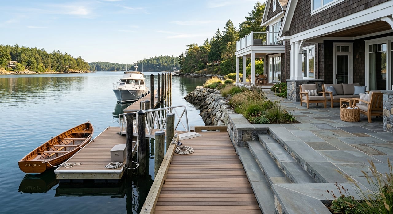
Days 5–14: inspect the pier and shoreline
Beyond the home inspection, schedule a marine contractor or pier specialist to evaluate the dock, lift, and shoreline stabilization. Ask for a written condition report with estimated remaining life and repair or replacement cost ranges.
Marine inspection checklist
- Pilings, framing, decking, and fasteners for rot, corrosion, and marine borer damage.
- Boat lift operation, hoist motors, and wiring, plus available service records.
- Shore power and dock electrical with GFCI protection and code compliance.
- Bulkhead or revetment condition, including signs of scour or undermining and any toe protection.
- Photos at low tide that show the approach channel, shoaling near the pier, and vegetation lines that help your surveyor and contractor confirm conditions.
Days 7–21: map flood risk and start insurance quotes
Flood exposure and insurance availability can affect both value and financing. Check the official FEMA maps for the exact address to see whether the home is in a Special Flood Hazard Area and to review the current Flood Insurance Rate Map panel. Use FEMA’s Flood Map Service Center.
- Ask for a current elevation certificate. It can refine your insurance rating and is often required by lenders for homes in high-risk zones.
- Get quotes early from both the National Flood Insurance Program and private carriers. FEMA’s updated pricing model, Risk Rating 2.0, looks at structure features, distance to water, and flood frequency, so quotes can vary even within the same neighborhood. Learn how Risk Rating 2.0 works.
- Plan your timing. A standard NFIP policy has a 30-day waiting period before coverage begins, with limited exceptions for loan closings. Starting early keeps your closing on track. Review FEMA’s waiting period rules.
Days 10–30: confirm water depth and approach
Pier length and water depth at mean low water determine real-world usability. In 21663, creeks and coves can shoal, and approach channels may need periodic maintenance.
- Call nearby marinas or the county Waterway Improvement office to confirm navigability, typical depths at low tide, and any recent dredging. Ask for the history, including the date, depth, and disposal location for any dredge work.
- If access depends on a community dredging district or shared maintenance agreement, request copies and a cost history so you can budget accurately. Understand Talbot County’s Waterway Improvement process.
During contingency: title, permits, and transferability
Read every permit related to the pier, bulkhead, and shoreline. Some state and federal permits include conditions that run with the property or require notice on ownership change. Others expire and would need re-approval for future work. Talbot County requires copies of Maryland Department of the Environment and U.S. Army Corps permits before it will issue a county zoning certificate for marine construction. If anything is missing or unclear, ask the seller to obtain copies or clarifications before you release contingencies. When questions arise, have your attorney or title company verify recorded rights and permit obligations.
Know the regulators before you plan changes
Waterfront rules operate at three levels. Understanding who does what will save you time and keep plans realistic.
Talbot County permits
Talbot County issues zoning certificates for new piers, bulkheads, revetments, dredging, and similar work, and enforces local floodplain and Critical Area rules. The county permit materials outline submittal items like site plans, proof of state and federal approvals, and notices to neighbors if lateral encroachment is proposed. Review the county marine permitting overview.
Maryland state approvals
Work in tidal wetlands or below mean high water typically needs a tidal wetlands license through the Maryland Department of the Environment. In many cases, you will use a joint application for state and federal review. The state’s Critical Area program also requires a minimum 100-foot vegetated buffer landward of mean high water and promotes living shoreline solutions for erosion control. See MDE’s tidal permits page.
U.S. Army Corps authorization
If work extends into navigable waters or includes dredging or fill, the U.S. Army Corps of Engineers may need to authorize it through a Nationwide Permit, a Regional General Permit, or an Individual Permit depending on impacts. Ask for copies of any Army Corps approvals and any required mitigation or maintenance conditions. Learn how federal permits work.
Pier length rule - verify first
Talbot County publications discuss maximum pier length and channelward extension, but two county documents use slightly different formulations. Because the numeric rule affects boating access, confirm the current standard directly with Planning and Zoning before assuming a specific pier length will be allowed. Check the county’s Pier Permit Guide.
Shoreline strategy: bulkhead or living shoreline
Maryland policy generally prefers living shorelines in many settings. These nature-based designs use plantings, sills, and limited rock to reduce erosion while supporting habitat. If you are evaluating a bulkhead replacement, ask a shoreline consultant to compare costs, feasibility, and approvals for both options. State programs provide guidance and, in some cases, technical assistance. Explore Maryland’s living shoreline guidance.
Your must-get document checklist
Use this quick list to keep everyone aligned during due diligence.
- Signed property survey with all structures and waterfront lines shown, including mean high water and mean low water if available. Learn how MHW affects ownership and permitting.
- Talbot County zoning permits for the pier, bulkhead, shoreline stabilization, dredging, and any final inspections or completion documents. See county permit guidance.
- MDE tidal wetlands licenses and U.S. Army Corps permits, including any mitigation or maintenance conditions. Review MDE’s tidal permits overview.
- Elevation certificate and any FEMA elevation documents.
- Septic and well records, recent tests, and environmental health inspection reports.
- Written dredging history if the pier relies on a dredged approach, including date, depth, permit, and disposal site. See the county’s Waterway Improvement page.
- HOA, marina, or community agreements that affect slips, dock maintenance, or shared dredging costs.
Who to hire and when
Specialists pay for themselves on the water. Line up the right team and schedule them within your contingency window.
- Licensed land surveyor to map boundaries, mean high water, and lateral lines. Background on MHW and tidal ownership.
- Marine contractor or pier inspector to assess pilings, framing, lifts, and electrical.
- Licensed septic inspector and well contractor for on-lot systems and water testing.
- Real estate attorney for deed language, riparian rights, easements, and permit transfer questions.
- Flood insurance agent to provide both NFIP and private quotes and to explain timing rules. Review the NFIP waiting period.
- Coastal or shoreline consultant where erosion is present or a living shoreline may be a better long-term solution. See Maryland’s living shoreline resources.
Local 21663 tips
St. Michaels area waterways can have varying depths and shoaling patterns. If you plan to berth a specific vessel, ask for low-tide soundings to mean low water and photos of the approach at dead low. If the community relies on dredging, request the district documents and assessment history up front. For process details and local contacts, the county’s Waterway Improvement page is a helpful starting point. Visit Talbot County’s Waterway Improvement page.
Bottom line
Waterfront due diligence in Talbot County is manageable when you work a clear plan: verify the survey and mean high water line, collect every permit, test the pier and shoreline, and scope flood and insurance early. Align your team and timeline so you can negotiate repairs, credits, or document updates while you still have leverage. If you want a steady hand from first look to closing, connect with a local advisor who has navigated complex waterfront deals many times.
Have questions about a specific property in 21663 or nearby? Let’s talk through your goals, your boat, your budget, and a clean path to closing. Robert Lacaze can help you evaluate value, manage risk, and move forward with confidence.
FAQs
Do Talbot County pier permits transfer when I buy a home?
- Not automatically. Some state or federal permits include conditions that require notice on ownership change or expire after a set period. Ask for all underlying MDE and U.S. Army Corps permits, plus county zoning certificates, and verify current status with the agencies before closing. Start with the county’s permit overview.
How long can a new pier be in Talbot County?
- County publications reference a 150-foot maximum and formulas for channelward extension, but two county documents use slightly different tests. Confirm the current rule with Planning and Zoning before assuming a length. See the Pier Permit Guide.
Do I need flood insurance for a Talbot County waterfront home?
- If the property is in a high-risk FEMA zone and you use a federally regulated mortgage, your lender will require flood insurance. Even outside high-risk zones, consider coverage due to proximity to water. Start quotes early because NFIP policies typically have a 30-day waiting period. Check your FEMA flood map and review NFIP timing rules.
Who maintains channels and pays for dredging near 21663?
- The U.S. Army Corps maintains certain federal navigation channels. Local recreational channels are often handled by dredging districts or community agreements that share costs. Ask for written dredging history and any district or HOA documents. Learn about the county’s Waterway Improvement process.
What is a living shoreline, and will Maryland prefer it over a bulkhead?
- A living shoreline uses plantings, sills, and limited rock to reduce erosion while supporting habitat. Maryland programs often prefer this approach in suitable settings and provide guidance and technical resources. Ask a shoreline consultant to compare feasibility and cost with bulkhead options. Explore state guidance.
Which agencies approve work below mean high water in Talbot County?
- You will typically need approvals from the Maryland Department of the Environment for tidal wetlands and, if work extends into navigable waters or involves dredging or fill, the U.S. Army Corps of Engineers. Talbot County requires proof of these approvals before issuing its zoning certificate. See MDE’s tidal permits and USACE regulatory guidance.