Wondering what your St. Michaels waterfront is really worth? In a small, high‑appeal market like ours, a few details can swing offers by six figures. You want clarity before you pick a price, commit to repairs, or choose the right moment to list. This guide shows you how buyers think about waterfront value, what rules and risks matter, and how to prepare a listing that commands respect.
Let’s dive in.
St. Michaels market, in real terms
Waterfront in St. Michaels is a micro‑market. Medians can jump month to month because a handful of high or low sales move the needle, and waterfront features vary widely across creeks and harbor edges. Inventory is usually limited, which rewards sellers who present a documented, move‑in ready property.
For context, county‑level trends help you track inventory and months of supply over time. You can review Talbot County market summaries in the Long & Foster Market Minute to frame timing and demand across the broader area. See the county snapshot for recent trend context.
Why the numbers vary so much
- The “waterfront” label covers everything from deepwater Miles River access to shallow, protected coves.
- Pier length, usable depth, and the ability to host a lift can change your buyer pool.
- Historic in‑town locations add walkability and charm, but they also add review steps for some projects.
Because of these differences, build your pricing from recent, hyper‑local comps within the past 6 to 12 months, matched for shoreline type, dock status, and water depth.
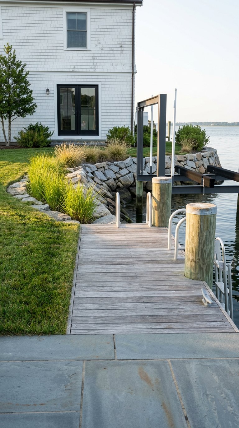
What buyers pay for on the water
Shoreline condition and type
Your shoreline is one of the first things waterfront buyers assess. Natural, vegetated edges and thoughtfully designed living shorelines read as resilient and attractive to many conservation‑minded buyers. For a clear overview of nature‑based stabilization methods and cost‑benefit tradeoffs, review the FHWA living shoreline implementation guide.
If you have a hard bulkhead, age and condition matter. A failing bulkhead invites price discounts because buyers price in replacement costs and permit risk. In Talbot County, sellers should document shoreline permits and repairs up front. The county’s marine permit guidance explains documentation and typical limits. See Talbot County’s marine permit information.
Dock, lifts, and water depth
A permitted, maintained pier with a usable slip or lift is a major value driver. Usability depends on permitted length, approach, lateral setbacks, and actual depth at your slip. County guidance caps many new piers at 150 feet or less and requires state and federal approvals first. Review Talbot County’s pier permitting basics and the Maryland Department of the Environment’s tidal permits page to understand sequencing and scope.
Buyer demand for boating access is strong given St. Michaels Harbor’s active marina network. Nearby facilities like Higgins Yacht Yard signal consistent harbor use, which supports the value of well‑documented private slips and lifts.
Access and exposure to Miles River
Direct, unobstructed access to deeper water and a short run to the Chesapeake Bay usually carries a premium for larger power and sail craft owners. Protected creeks appeal for swimming and paddle craft but may limit draft. Exposure to wind and fetch is a tradeoff: more exposure can require sturdier docks and more maintenance. Price by matching comps with similar access, depth, and exposure.
Historic district and in‑town walkability
Properties inside or adjacent to the nationally recognized St. Michaels Historic District often benefit from walkability to restaurants and the Chesapeake Bay Maritime Museum. At the same time, design controls and added review can affect some waterfront and shoreline projects. You can confirm the district’s status in the Maryland Inventory of Historic Properties file. If your property is in or near the historic core, gather prior approvals and plans before listing.
Flood‑resilient upgrades and documentation
Flood exposure is top of mind for many buyers. Elevation certificates, elevated utilities, flood vents, and resilient lower‑level materials reduce uncertainty and can support stronger offers. Talbot County provides flood zone resources, the county’s NFIP Community Rating System status, and guidance on how to document risk. Start with the Talbot County flood information page and use it to confirm your flood zone and available credits.
Rules and risks that shape value
Permit sequence and timing
Marine work in Talbot County generally requires approvals in a specific sequence. You apply with the Maryland Department of the Environment and, when applicable, the U.S. Army Corps of Engineers before seeking a county zoning permit. The county zoning permit fee is modest, but state and federal reviews drive the timeline. If you have existing docks or bulkheads, repair and maintenance can follow different rules than new construction. Read the MDE tidal permitting overview and confirm your file history in the Talbot County marine permit guide.
Chesapeake Bay Critical Area and the 100‑foot buffer
If your parcel sits in the Critical Area overlay, buffer rules influence what you can remove, plant, or build within 100 feet of tidal waters and wetlands. Decking width, walkway design, and buffer mitigation are regulated, and fees or plantings may be required. Review the Town and County buffer management standards to understand constraints and options. Start with the Critical Area buffer code section.
Flood zones, insurance, and buyer confidence
Talbot County participates in the NFIP Community Rating System as a Class 7 community, which can mean premium discounts for qualifying properties. Many insurers and lenders ask for an Elevation Certificate when a home is in or near a Special Flood Hazard Area. Having that document ready, along with a concise summary of any mitigation, removes a major friction point for buyers. Use the county flood information portal to check your zone and gather resources.
Sea level rise and high‑tide flooding
Buyers often ask about future flood scenarios. The NOAA Sea Level Rise Viewer is a clear way to visualize relative inundation and high‑tide trends in your area. Pair the tool with your lot’s known elevations for a grounded discussion. Explore the NOAA Sea Level Rise Viewer.
Sewer vs septic and marketability
Public sewer access, or a defined plan for extension, reduces buyer anxiety about future system replacement. Where a property remains on septic, current inspection or pump reports help maintain pricing power. For regional wastewater context and resilience planning, review Talbot County’s Hazard Mitigation and Community Resilience Plan and confirm current service with the County.
A pricing strategy that commands respect
Smart pricing starts with two comp sets.
- Set A: Waterfront comps on the same creek or harbor with similar shoreline conditions, permitted pier length, number of lifts, and documented water depth.
- Set B: In‑town, walkable comps that capture the value of historic character and proximity to Talbot Street amenities.
When waterfront comps are thin, carefully extend the search and adjust for access, exposure, and dock features. Explain adjustments in plain language. For example, note differences in permitted slips versus no slip, direct Miles River access versus a shallow cove, or newly permitted living shoreline versus an aging bulkhead. Buyers respond to transparent, well‑supported logic.
Pre‑listing prep that moves the needle
A little discipline before you list can shorten days on market and protect your asking price.
Gather documents early
Have these items ready to share with buyers, inspectors, and appraisers:
- Current survey showing property lines and lateral setbacks to the waterway.
- Copies of pier, bulkhead, and shoreline permits or exemption letters, plus any maintenance records. See the Talbot County marine permit guidance.
- Elevation Certificate if your property is in or near a flood zone. Confirm resources via Talbot County flood information.
- Septic inspection or recent pump report, or documentation of public sewer connection.
- Historic district approvals, if applicable, and any architectural plans related to shoreline or exterior work.
Order targeted inspections
- Pier and lift inspection focused on structural safety, mooring pilings, electrical service, and lift operation.
- Shoreline and bulkhead assessment with estimated remaining life and repair options, including living shoreline feasibility. For background on nature‑based options, reference the FHWA living shoreline guide.
- Whole‑home mechanical and roof check to surface issues before buyers do.
Prioritize cost‑effective fixes
- First, resolve safety and code items at the pier and shoreline.
- Second, clear permits and documentation for dock and shoreline features.
- Third, handle mechanical or roofing issues that could derail an inspection.
- Fourth, make targeted curb‑appeal upgrades like fresh dock decking, serviced lifts, and native buffer plantings along the water side.
A 12 to 18‑month playbook
If you have time, you can stage the work to reduce surprises and add value.
- Months 1 to 3: Confirm flood zone and order an Elevation Certificate. Pull permit history and surveys. Book shoreline and pier inspections. Begin any straightforward maintenance.
- Months 4 to 6: Decide on necessary shoreline work and apply for permits if needed. Schedule lift service and minor dock repairs. Gather septic or sewer documentation.
- Months 7 to 9: Complete shoreline work, finalize any historic or Critical Area approvals, and package all documents into a clean buyer packet.
- Months 10 to 12: Refresh landscaping, complete interior touch‑ups, and finalize your pricing comps and disclosures.
- Months 12 to 18: Watch inventory and trend context at the county level and be ready to list when competing supply is light. Reference the Talbot County market summary for broader signals, then lean on very recent local comps to set the price.
Bottom line for thoughtful sellers
The strongest offers in St. Michaels go to waterfront homes that remove uncertainty. Document your shoreline, permit status, and flood risk. Make targeted repairs that matter at the water’s edge. Then price from recent, water‑specific comps that fit your exact setting and access.
If you want a valuation‑first plan tailored to your property, connect with Robert Lacaze. Let’s build a strategy that protects your time and your net.
FAQs
How do St. Michaels waterfront values differ from non‑waterfront homes?
- Waterfront pricing reflects shoreline condition, dock permits and depth, and access to Miles River or protected creeks, which create wider spreads than in‑town sales.
Which shoreline fixes add the most value before listing?
- Address safety and structural issues first, then secure or renew permits; living shoreline solutions can appeal to buyers where appropriate, per the FHWA guide.
What permits do I need to repair or extend my dock in Talbot County?
- Most projects require Maryland Department of the Environment approval and often U.S. Army Corps review before a county zoning permit; start with MDE’s tidal permits and the county marine permit guide.
How can I show buyers my flood risk accurately?
- Order an Elevation Certificate and share a concise mitigation summary; use Talbot County’s flood information portal and the NOAA Sea Level Rise Viewer for context.
Do Critical Area rules affect my home’s value?
- Yes. The 100‑foot buffer and mitigation requirements can limit expansion but also guide attractive, compliant designs; review the Critical Area code section.
Will access to public sewer help my sale?
- It can. Documented public sewer or a defined extension plan reduces buyer concern about future septic costs; consult the county’s resilience plan and confirm current status with officials.